Nunavut
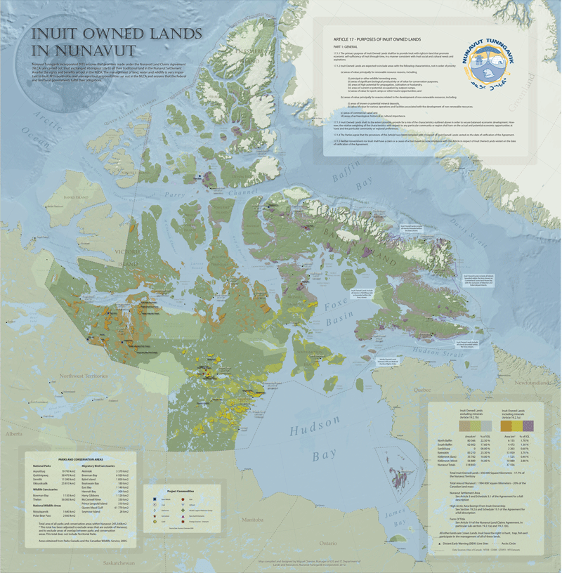
Nunavut, which means “Our Land” in Inuktut, is the newest, largest and northernmost territory of Canada. It was officially created on April 1, 1999, though the proposed boundaries had been drawn in 1992 after a plebiscite was held to confirm the division between Northwest Territories and Nunavut. In October 1992, the Nunavut Land Claims Agreement was put to a plebiscite and saw a resounding majority of voters pass the agreement with a nearly 85 per cent majority. In May 1993, the Nunavut Land Claims Agreement was signed in Iqaluit, and on June 10, 1993, the NLCA and the Nunavut Act (an act that created the new territory) were passed.
Nunavut covers 1,936,113 square kilometres of land and 157,077 square kilometres of water in Northern Canada, representing 21 per cent of the country’s total area.
Nunavut covers 1,936,113 square kilometres of land and 157,077 square kilometres of water in Northern Canada, representing 21 per cent of the country’s total area. The territory includes mainland Canada, the majority of the Arctic Archipelago, and all of the islands in Hudson Bay, James Bay (including Akimiski Island and Charlton Island) and Ungava Bay. Nunavut also includes Ellesmere Island as well as the eastern and southern portions of Victoria Island in the west. Renamed in 1987 from Frobisher Bay, the capital of Nunavut is Iqaluit. All areas of Nunavut are accessible only by plane or boat.
Nunavut is a territory that consists of three regions: the Qikiqtaaluk (Baffin) Region, the Kivalliq Region and the Kitikmeot Region. These regions are marked by stark differences in geology and more subtle differences in culture. The environment and wildlife in the regions have led to differences in diet and hunting techniques as well as dialects of Inuktut.
Qikiqtaaluk Region
The Qikiqtaaluk Region is the easternmost administrative region of Nunavut. Qikiqtaaluk is the traditional Inuktitut name for Baffin Island. There are 13 communities in the Qikiqtaaluk Region: Iqaluit, Arctic Bay (Ikpiarjuk), Cape Dorset (Kinngait), Clyde River (Kangiqtugaapik), Grise Fiord (Ausuittuq), Hall Beach (Sanirajak), Igloolik (Iglulik), Kimmirut, Pangnirtung, Pond Inlet (Mittimatalik), Qikiqtarjuaq, Resolute (Qausuittuq) and Sanikiluaq.

Kivalliq Region
The Kivalliq Region consists of the portion of the mainland to the west of Hudson Bay together with Southampton Island and Coats Island. There are seven communities in the Kivalliq Region: Arviat, Baker Lake (Qamani’tuaq), Chesterfield Inlet (Igluligaarjuk), Coral Harbour (Salliq), Naujaat, Rankin Inlet (Kangiqtiniq) and Whale Cove (Tikirarjuaq). It is here that you will find the great expanse of the Arctic tundra — rolling hills that stretch from horizon to horizon. This is also home to some of Nunavut’s largest lakes and rivers.
Kitikmeot Region
The Kitikmeot Region is the most western region of the territory and consists of the southern and eastern parts of Victoria Island with the adjacent part of the mainland. There are five communities in the Kitikmeot Region: Cambridge Bay (Ikaluktuuttiak), Gjoa Haven (Uqsuqtuuq), Kugaaruk, Kugluktuk and Taloyoak.
Order now
from Amazon.ca or Chapters.Indigo.ca or contact your favourite bookseller or educational wholesaler